Bits of CliftonPhotographed in July 2004 |
|
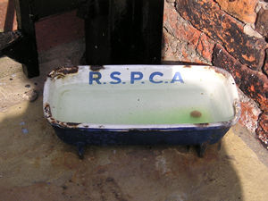
This small water trough stands by a house on Clifton. It's been there for as long as I can remember, its enamel coating loosening slightly round the edges, but the letters R.S.P.C.A still clearly visible. I've never seen a dog or any other creature drinking from it, I've got no idea where it came from (well, the RSPCA, presumably) or why it's in this particular street, and I've never seen another like it. But I love it being there. Someone at some time thought they'd put a small water dish out for the dogs to drink from on a hot day, and it's still there. Bless it, and its chipped enamel. |
 |
|
|
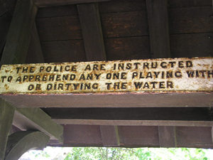
This sign reads: "The police are instructed to apprehend any one playing with or dirtying the water". It's nothing to do with the water dish illustrated above, but it is attached to another generously donated water receptacle for animals. It's underneath the roof of the horse trough on Clifton Green, pictured below. |
 |
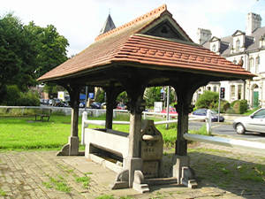 |
The trough dates from 1883. Miss Maria Husband, who lived in the area, donated a generous sum and also collected other donations to pay for its construction. Though I've called it a horse trough, it does apparently incorporate a dog trough, lower down. So there should be no thirsty dogs in Clifton, with this and the RSPCA trough (above). It won't be used much by horses, as there are none around on the green these days, just lots of cars passing by.
|
A detour into street namesThe street names in York can be rather confusing. Bootham and Clifton are good examples. Both are the names of roads, but Clifton is also the name of an area – which used to be a village and is now more of a suburb. The road that leaves the city centre from Bootham Bar is called Bootham, and at an apparently random point about half way down it turns into "Clifton" – a street – which leads to the village/suburb of the same name. Perhaps because of this general confusion, many visitors to the city add "road" or "street" to the end of "Bootham". Just recently I had someone stop me to ask for directions to "Bootham Road". This tends to confuse matters, as off Bootham there are streets called Bootham Terrace and Bootham Crescent, and at the top near town there's a car park called Bootham Row. Being a native old Yorkie I find it's best to clarify which road is required by using other landmarks or symbols. If you see someone in a football shirt, it's a lot easier, as the clothing often signifies that they're looking for Bootham Crescent. This, as well as being the name of a street, is also the name of our football ground. Which isn't actually on Bootham Crescent, but Grosvenor Road. Confusing, isn't it. |
|
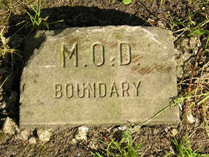
In the middle of a grass verge on Burton Stone Lane are several of these marker stones, stating "M.O.D BOUNDARY". I assume this is something to do with the Lumley Barracks site on the corner of Burton Stone Lane and Grosvenor Road, most of which was sold off for housing some years ago, though part of it is still in use. I don't know why the M.O.D (Ministry of Defence) has to mark its territory in this way, or what happens if you walk over to the other side of this stone -maybe someone shoots you. I'm probably down in a file somewhere now, caught on their CCTV taking this photo and looking inadvertently like an international terrorist. |
 |
|
|
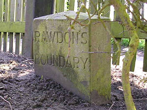
Another interesting boundary stone has been discovered by Tom and Keith, who told me about the marker for "Rawdon's Boundary", pictured right. The stone stands in the grounds of St Peter's School, just inside their boundary hedge, where, on the other side of the hedge, two public rights of way meet. (See Clifton footpaths, part 1 and part 2) If anyone visiting this page has any information about the stone, please contact me via the link at the foot of the page. |
 |
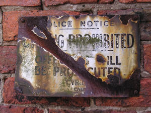 |
I photographed this old worn sign near Clifton Green for two reasons. Firstly, it looks like before too long it may be totally unreadable, rather than almost totally unreadable as it is now. Secondly, I like old signs – as you might have noticed. Thirdly (okay, three reasons), these signs take me right back to childhood, and in particular a snicket (aka short-cut, snickelway) in Acomb, which had a sign just like this one. It says "Police Notice – CYCLING PROHIBITED – OFFENDERS WILL BE PROSECUTED" – and it reminds me of the 1970s and boys on their Raleigh Choppers taking no notice of it whatsoever. |
|
|
(While taking that short wander down "Memory Lane", I forgot to mention that the sign is on the wall at the beginning of a snicket (footpath) through Clifton.) |
||
 |
 |
|
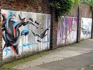 |
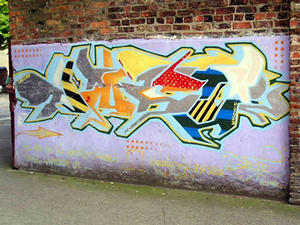
This artwork appears on a wall down the side of the old Clifton cinema – now a bingo hall. Because it's on a wall, and outside, and displayed for free, you might call it graffiti. It looks as if this was "commissioned" in some way, as the walls have been covered with rendered panels for the purpose. (Update: Apparently it was by Part 2 – as were the other works which later covered these walls – see autumn 2004 page and autumn 2006 page.) |
|
|